Emilia-Romagna
region in Italy From Wikipedia, the free encyclopedia
Remove ads
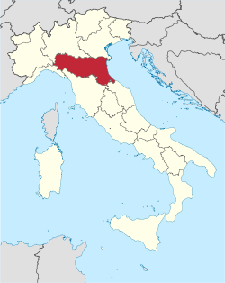
Emilia-Romagna (Emilian: Emégglia-Rumâgna, Emîlia-Rumâgna, Romagnol: Emélia-Rumâgna) is one of the twenty regions of Italy, in northeast Italy on the Adriatic Sea. The capital is Bologna.
Remove ads
Geography
The region is in Northern Italy with an area of 22,452.78 km2 (8,669.07 sq mi).[4] It is bordered to the north by the Veneto and Lombardy regions, to the northwest by the Piedmont and Liguria regions, to the west by the Tuscany, to the south by the Marche region and the republic of San Marino, and the Adriatic Sea to the east.
The main river in the region is the Po. The highest mountain in the region is Monte Cimone, in the northern Apennines, with an altitude of 2,165 m (7,103 ft).
Provinces
Emilia-Romagna has nine provinces grouped in two historical regions:
- Emilia, with the provinces Ferrara, Modena, Parma, Piacenza, Reggio Emilia and part of Bologna.
- Romagna, with the provinces Forlì-Cesena, Ravenna, Rimini and part of Bologna.

Largest municipalities
The 10 comuni with more people living in it are:
Remove ads
Gallery
References
Other websites
Wikiwand - on
Seamless Wikipedia browsing. On steroids.
Remove ads


