Top Qs
Timeline
Chat
Perspective
Kagawa Prefecture
Prefecture of Japan From Wikipedia, the free encyclopedia

Remove ads
Kagawa Prefecture (香川県, Kagawa-ken, Japanese pronunciation: [kaꜜ.ɡa.wa, -ŋa.wa, ka.ɡa.waꜜ.keɴ, -ŋa.waꜜ-][4]) is a prefecture of Japan located on the island of Shikoku.[5] Kagawa Prefecture has a population of 949,358 (as of 2020)[2] and is the smallest prefecture by geographic area at 1,877 square kilometres (725 sq mi).[1] Kagawa Prefecture borders Ehime Prefecture to the southwest and Tokushima Prefecture to the south.
This article needs additional citations for verification. (October 2018) |


Takamatsu is the capital and largest city of Kagawa Prefecture,[6] with other major cities including Marugame, Mitoyo, and Kan'onji. Kagawa Prefecture is located on the Seto Inland Sea across from Okayama Prefecture on the island of Honshu, which is connected by the Great Seto Bridge. Kagawa Prefecture includes Shōdoshima, the second-largest island in the Seto Inland Sea, and the prefecture's southern land border with Tokushima Prefecture is formed by the Sanuki Mountains.
Remove ads
History
Kagawa was formerly known as Sanuki Province.[7]
For a brief period between August 1876 and December 1888, Kagawa was made a part of Ehime Prefecture.[8]
Battle of Yashima
Located in Kagawa's capital city, Takamatsu, the mountain of Yashima was the battlefield for one of the best-known struggles between the Heike and Genji clans.
Geography
Summarize
Perspective
Kagawa comprises the northeast corner of Shikoku, bordering Ehime Prefecture on the west and Tokushima Prefecture on the south, with a coastline on the Seto Inland Sea facing Okayama Prefecture and the Kansai. The Sanuki Mountains run along the southern border.
Kagawa is currently the smallest prefecture, by area, in Japan. Kagawa is a relatively narrow prefecture located between the mountains of Shikoku and the sea.
As of April 1, 2012, 11% of the total land area of the prefecture was designated as Natural Parks, namely Setonaikai National Park and Ōtaki-Ōkawa Prefectural Natural Park.[9]
Cities

City Town


Eight cities are located in Kagawa Prefecture:
Towns
Kagawa has eight towns organized into five districts. Many were created after 1999 through mergers, as part of a national effort to reduce the number of small towns and villages.[10]
Mergers
Remove ads
Economy
Kagawa has a nominal GDP of approximately 3,802 billion yen.[12] Kagawa's major export industries, in order of export value, include transportation equipment, electrical equipment, chemical products, general machinery, mineral fuels, manufactured goods, raw materials, and foodstuff.[13]
Foods
Summarize
Perspective

Sanuki udon (a type of udon noodle) is the most famous local food of Kagawa Prefecture. In 2008, there were over 700 udon restaurants in this prefecture alone.[14]
Aside from udon, Kagawa is also famous for "hone-tsuki-dori", seasoned chicken thigh cooked on the bone. Originating from Marugame City, the dish has now become a popular dish in izakaya restaurants across the country.
Olives and olive-related products have also come to be recognized as Kagawa foods. As the first place in Japan to successfully cultivate olives, Kagawa has been producing olive-related products since 1908. As well as winning both domestic and international awards for the quality of its olive oil, Kagawa has also created two offshoot food brands from its olive industry - "olive beef" and "olive yellowtail". Waste organic matter from olive pressing is used as feed for cattle and the Yellowtail Amberjack. Due to the high amount of polyphenols in the olive waste, the flesh of the respective meats does not oxidize or lose color easily.
Other local specialties include wasanbon sugar sweets, sōmen noodles and shōyu soy sauce. Rare sugar researches are thriving and have discovered mass production culture enzymes. D-tagatose 3-epimerase is an enzyme that catalyzes the reversible epimerization reaction of the 3rd carbon of ketose.
Remove ads
Demographics

As of October 2020, Kagawa Prefecture had an estimated population of 950,244. This was 7.1% lower than the population in the 2000 census, being 1,022,890. The area of the prefecture is 1,877 km, and the population density is 506.3/km.[15]
Education
Universities
- Kagawa Prefectural College of Health Sciences
- Kagawa University in Takamatsu
- Shikoku Gakuin University in Zentsuji
- Tokushima Bunri University in Sanuki
- Takamatsu University
Sports

The sports teams listed below are based in Kagawa.
Baseball
Basketball
Football (Soccer)
Volleyball
Ice Hockey
- Kagawa Ice Fellows (see Japan Ice Hockey Federation)
Tourism
Summarize
Perspective


- Kotohira
- Manno
- Manno Lake
- Sanuki Manno National Park
- Marugame
- Sakaide
- Kagawa Prefectural Higashiyama Kaii Setouchi Art Museum (Kaii Higashiyama`s Art Museum)
- Mount Iino (Kagawa's Mount Fuji)
- Kiyama (a castle ruins)
- Shinto shrine (misasagi) (Emperor Sutoku's Tomb)
- Fuchu Dam
- Great Seto Bridge
- Mitoyo
- Chichibugahama Beach
- Takaya Shrine
- Higashi Kagawa
- Hiketa Castle - A castle ruin, one of the Continued 100 Fine Castles of Japan in 2017.[16]
- Naoshima Island
- Ando Museum
- Benesse House
- Chichu Art Museum
- Lee Ufan Museum
- Setonaikai National Park
- Shikoku Pilgrimage – Zentsū-ji, Motoyama-ji, Yashima-ji, etc.

- Shodoshima
- Kankakei Gorge
- Shodoshima Olive Park
- Nakayama Senmaida
- Takamatsu
- Megijima and Ogijima
- Ritsurin Garden
- Takamatsu Castle
- Yashima, the island on which the Battle of Yashima was fought
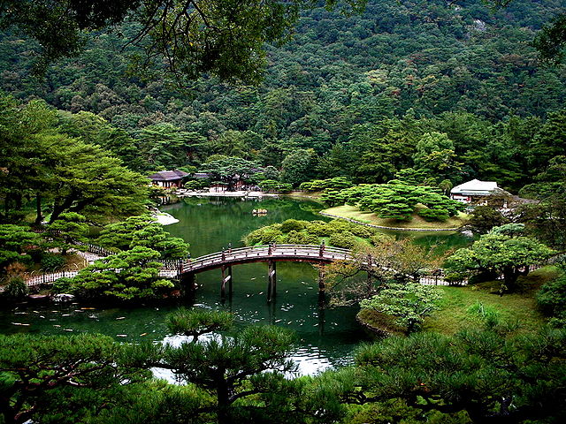
Ritsurin Garden
- Teshima Island
- Shima Kitchen
- Teshima Art Museum
- Kan'onji
- Zentsūji

Based on its ancient name, Sanuki, Kagawa is famous for its Sanuki udon (wheat noodles). Recent years have seen an interest in Sanuki udon across Japan[citation needed], and many Japanese now take day-trips to taste the many Sanuki udon restaurants in Kagawa.
Remove ads
Transportation
Railroad
- JR Shikoku
- Kotoden (Takamatsu Kotohira Electric Railroad)
- Kotohira Line
- Nagao Line
- Shido Line
Bus
Departure from Takamatsu
Road
Expressway
National highways
 National Route 11 (Tokushima-Takamatsu-Marugame-Niihama-Maysuyama)
 National Route 30
 National Route 32 (Takamatsu-Kotohira-Kochi)
 National Route 193
 National Route 318
 National Route 319
 National Route 377
 National Route 436
 National Route 438
Port
- Port of Marugame
- Port of Tadotsu
- Port of Takamatsu – Ferry route to Uno, Tonoshō (Shōdoshima Island), Kobe, Naoshima
- Port of Tonoshō – Ferry route to Okayama, Himeji, Kobe and Osaka.
Airport
In popular culture
- Shōdoshima is the setting of the novel Twenty-Four Eyes by Sakae Tsuboi and its subsequent film adaptations.
- In Pom Poko, the tanuki Tamasaburo Onigamori travels to Shikoku to ask the Transformation Masters to come to Tokyo to save Tama Hills from destruction, but he marries and settles there for three years.
- The manga Teasing Master Takagi-san is also set on Shōdoshima, in Tonoshō the native place of the creator, Sōichirō Yamamoto
- The novel Battle Royale by Koushun Takami was set in the fictional town of Shiroiwa ('Castle Rock') in Kagawa Prefecture. Okishima, the fictional island on which much of the novel takes place is placed in the Seto Inland Sea. The manga also places Shiroiwa in Kagawa, while the film moves Shiroiwa to Kanagawa Prefecture.
- The city of Takamatsu is the main setting of the book "Kafka on the Shore" by Haruki Murakami.
- Kan'onji is the setting of the early parts of the manga My Bride Is a Mermaid as well as the anime series Yuki Yuna is a Hero.[17]
- Poco's Udon World.
Remove ads
Notes
- Estimate. Part of boundary between Okayama and Kagawa is undefined.[1]
References
External links
Wikiwand - on
Seamless Wikipedia browsing. On steroids.
Remove ads